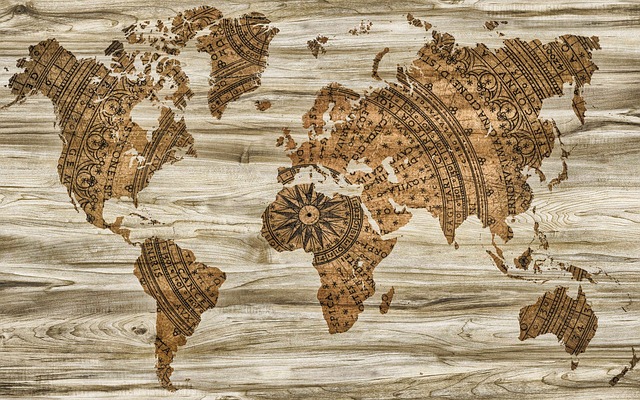
Europe in the centre and the world pretty much around it. A mere coincidence or a remnant of the world’s colonial past?
The positioning of hemispheres on the world map resulted from an interplay of various factors such as history, culture, religion and psychology. Let’s begin with understanding the human psychology behind mapping the world.
A lot of species, including human beings, possess specialised brain areas to create cognitive maps of their surroundings. However, what makes humans different is that they want to communicate that information as well. As a result, maps as early as those made during stone age have been found carved on rocks. This picture is of Imago Mundi, a Babylonian clay tablet map from 600 B.C., also known as the oldest known world map.
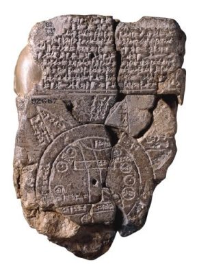 (Imago Mundi, 600 BCE Babylonia)
These maps suggest that during 5th and 6th centuries BCE, flat earth paradigm was widely believed. It was only during the Hellenistic period that an understanding of spherical earth began appearing.
Anaximander, a pre-Socratic Greek philosopher, from the 6th century BCE is credited as the creator of one of the first maps of the world. It was circular and showed known landmasses grouped around the Aegean sea, which lied in the center. All of this was surrounded by the ocean, as can be seen in the reconstruction of his map below:
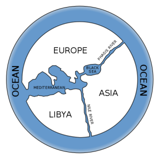 (Reconstruction of Anaximander’s map)
Just like with all endeavours, scholars began to improve upon old maps through newly acquired knowledge from travellers’ accounts. Prominent among these were Hecataeus of Miletus, Eratosthenes, Pomponius Mela and Strabo, and Ptolemy World map came around the same time.
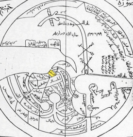
Religion played a significant role in mapmaking in several cultures too. For example, early Islamic maps show South direction on the top because it is the direction of their holy city of Mecca and the direction in which Muslims are supposed to pray 5 times a day. Further, the earth is encircled by sea and surrounded by fire, an idea from Quran, as shown below:
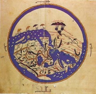 (Early Islamic map)
Another example of incorporating Islamic influence in a map can be seen in Ibn Hawkal’s map of the world. Ibn was an Arab scientist in the 10th century and this map is said to be based on his travels. It also shows South direction on the top:
 (Ibn Hawkal’s world map)
Similarly, a variety of Christian maps also emerged in the same era that often showcased the East direction on the top, thereby placing Garden of Eden on the top as well as Jerusalem in the centre of the world. Here is the Ebstorf Map, one of the many maps of this tradition. It has Rome represented in the shape of a lion and the top of the map depicts the head of Christ.
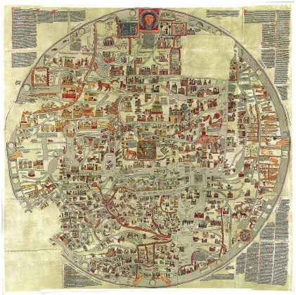 (The Ebstorf Map)
So basically, there was no established standard answer for the “What lies at the top of the world?” question.
Europe wanted to place North Pole at the top and end up in the centre thereby and some ancient Chinese maps seemed to agree with Europe on the top positioning of North Pole, for pretty different reasons. Map experts suggest that it was mostly done to place the position of Chinese emperor, who lived in the north of the country, on the top.
Cultural influence also played a significant role, as can be seen in the case of Da Ming Hunyi Tu, which translates to ‘Amalgamated Map of the Great Ming Empire’. It shows China in the centre (surprise surprise!) and Europe, half-way round the globe, depicted horizontally compressed and very small. Nearby coasts, including the Coast of Africa, are shown from an Indian Ocean perspective.
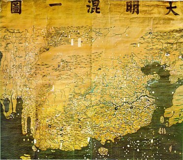 (Da Ming Hunyi Tu map)
As the Age of Discovery began, every other explorer came up with maps based on their travels combined with existing knowledge as well as their personal preference. The positioning of North pole at the top became popular only when Europe became a centre of map production in the 16th century.
However, the biggest breakthrough came in 1569 with a Flemish geographer and cartographer Gerardus Mercator, who introduced a cylindrical map projection. It was eventually called as the Mercator projection and was adopted by seafaring nations of that time, which were mostly European.
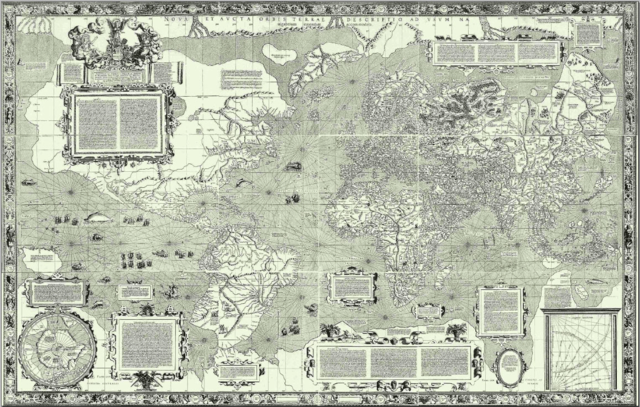 (The Mercator map of 1569)
It had North positioned up and this understanding of geography went to places far and wide and demolished regional maps. The North-up idea stuck and thus, the northern hemisphere became the ‘top’ of the world, as we know it today.
(All image sources, courtesy of Wikipedia)
Copyright © Neha Sharma

Thanks for the reblog 🙂
LikeLike
This was interesting…so many theories around the map. That was the true age of explorers , inventors ,thinkers …….we the privileged lot got things on the platter.
LikeLiked by 2 people
Very true, Sakshi. We are indeed the lucky ones 🙂
LikeLike
🤗👌
LikeLiked by 1 person
Interesting piece of information! Great post Neha!!
LikeLiked by 1 person
Thanks a lot, Kranti ❤
LikeLike
You’re a total brainiac! I love History.
LikeLiked by 1 person
You are too kind with compliments, my dear Rakkelle ❤ ❤ But I will take it 😀 😀
LikeLiked by 1 person
very interesting article! was a good read
LikeLiked by 1 person
Thank you 🙂
LikeLike
I am glued to find out more now. Thanks for this informative post Neha
LikeLiked by 1 person
I am glad it intrigued you, Parikhit. History is always fascinating 🙂
LikeLike
Very good historical review of the topic. Well done, Neha!
LikeLiked by 1 person
Thanks a lot for the compliment. So glad you liked it 🙂
LikeLiked by 1 person
Very interesting 👍…. I’ve saved this post, would like to read again.
Glad that i found your blog site, really. 😊
LikeLiked by 1 person
Thank you for such a nice compliment! I am so glad you liked this post 🙂
LikeLiked by 1 person
An interesting map is the Oronteus Finaeus map of 1532. Have you hear of it?
LikeLiked by 1 person
Hey Rob. I haven’t read about this one but I will surely do, now that it has been recommended so strongly 🙂
LikeLike
And, quite possibly, maps of the world will undergo further change yet. This is one of my favourite (funny, yet sadly, true) maps of the world. https://brilliantmaps.com/new-yorkers-world/
LikeLike
I agree on that. There is so much to be discovered! Also, the map you linked to is pretty funny 😀
LikeLiked by 1 person
Funny, and ,unfortunately, still almost as true as when it was first published.
LikeLiked by 1 person
I think such a worldview is true for residents of all major cities. Just about everything we need is round the corner, so we hardly need to step out. 🙂
LikeLiked by 1 person
Yes. I know when I was living in New York, it was easy to be seduced into the world view portrayed by the poster.
LikeLiked by 1 person
😀 😀
LikeLiked by 1 person
Beautiful read. In my book I have a section on cartographer. So I did a brief studies on map.
LikeLiked by 1 person
This sounds amazing. When am I getting to read this book? 😀
LikeLiked by 1 person
Yet to be published dear. You can read the synopsis here https://ckonfab.com/thelastscintilla/
LikeLiked by 1 person
Very interesting synopsis. Looking forward to it 🙂
LikeLiked by 1 person
Thank you so much, Neha ❤️❤️
LikeLiked by 1 person
🙂
LikeLiked by 1 person
wow Neha ! your topics are so different and out of this world and always give us some new information.Thanks 🙂
LikeLiked by 1 person
Thank you so much for such a beautiful compliment. I am so glad my content interests a person of your calibre 🙂
LikeLike
It”s the truth though.
LikeLiked by 1 person
You are really sweet ❤
LikeLiked by 1 person
Very interesting write.
LikeLiked by 1 person
Thanks Drew! So glad you found it interesting 🙂
LikeLike
Hey, Neha I have nominated you for Freedom of expression Tag
https://sparkklingthoughts.wordpress.com/2018/08/09/freedom-of-expression-believe. Thank you 🙂
LikeLiked by 1 person
Hey Kranti. Thanks for the tag. I will definitely get back to you on this soon ❤
LikeLiked by 1 person
No problem dear!! You are so welcome ❤️
LikeLiked by 1 person
❤ ❤
LikeLiked by 1 person
Fascinating post. Thanks Neha!
LikeLiked by 1 person
Thank you for reading it, Karen. I am glad it interested you 🙂
LikeLike
This is very interesting!
LikeLiked by 1 person
Thank you! I am glad you found it interesting 🙂
LikeLiked by 1 person
You’re welcome!
LikeLiked by 1 person
🙂
LikeLiked by 1 person
Awesome article Neha, I never really gave
LikeLiked by 1 person
(*continue*) I never really gave much thoughts to maps, but your article really expanded my knowledge. Thanks for sharing!😀👌
LikeLiked by 1 person
I am so, so pleased that it interested you ❤ ❤
LikeLike
Such a fascinating read. Thanks a lot for writing.
LikeLiked by 1 person
Thank you, Abhinav 🙂
LikeLiked by 1 person
Hey, this was absolutely interesting. Loved to have read it.
LikeLiked by 1 person
I am so glad you found it interesting ❤
LikeLiked by 1 person
Fascinating! A different topic to write on – I’m happy I came across your blog and had a chance to read it. 🙂
LikeLiked by 1 person
Thanks a lot for reading it, Sindhuja! Welcome to Literary Lemonades ❤ ❤
LikeLiked by 1 person
Fascinating history.
LikeLiked by 1 person
Thank you, Brenda ❤
LikeLiked by 1 person
The first map, Imago Mundi, looks so very different from what we use today, but the purpose was the same: communication. Amazing, isn’t it?
I didn’t know that there are maps showing south or east on the top. Thanks for such an informative and interesting post, Neha… 🙂
LikeLiked by 1 person
Thank you for reading it so intently! I am so happy you found it interesting enough 🙂 🙂
LikeLiked by 1 person
I really enjoyed it… 🙂
LikeLiked by 1 person
Thank you ❤
LikeLike
How fascinating!!! You did a lot of research for this and I love when I learn something here!! What I have learned most blogging is connecting with the world…the real world and hearing from people what life is like here, there…a very intriguing and informative post, my dear.
LikeLiked by 1 person
Thank you so much for reading this, Cheryl. The fact that it intrigued you makes me happy ❤
LikeLike
Today`s world maps are still based and continuously updated versions of the ones the European explorers, seamen and navigators (very famous are the Portuguese ones) have originally created. In fact, the Europeans belong to the first global exploreres, who crossed all 7 oceans & continent – and which is important, were used to conserve ad multiplicate Knowledge by writing and map design (e.g. in contrast to the Vikings or Polynesian cultures). Of Course, the European continent is placed in the middle of the word-map due to the fact that it was the origin of their expeditions – using hub-spoke networks (origin – destination routes only) at the begining of the era of exploration. This discovery period that led to the first world maps started BEFORE colonialism. But of course, the expeditions enabled colonialsm later on and resulted in the establishment of a global, well-connected trade network, cultural Exchange and leverage of Know-how. The(sea) maps were treated strictly confidenial for a long time.
LikeLiked by 1 person
The hub-spoke network analogy is such a wise way to express this idea. I agree that the first maps began long back before colonialism but it was the leading factor later on in the spread of European ideas to the world. It couldn’t have been explained better than how you have explained it in your comment. Thanks for that 🙂
LikeLiked by 1 person
Thank you for the interesting article, Neha!
Great idea to provide an insight into this Topic. I don´t admire just their boldness but als their capabilities for critical thinking nd determination to challenge their fate against all resistance of all group of stakeholders in society.
By the way, I hhad the opportunity to visit Portugal in the past. Standing at the Edge of the cliffs Looking to the horizon of the Atlantic Ocean, I could FEEL the navigators legacy. Surprisingly, it was a very touching moment. Very strange to know that These courageous people probably stood at the same spot. Imagine that they were convinced that they will reach the end of the world at the horizon, while others questioned the concept of a flat world and wee tortured & killed by the monarchs & the Christian church for their idea that the world might be a globe.
LikeLiked by 1 person
This sounds like a wonderful experience, Weiss! I guess that this is true for all human endeavours really; in whichever discipline we look into, we are just standing on the shoulders of giants. It is so humbling and empowering at the same time 🙂
LikeLike
Very interesting read
LikeLiked by 1 person
Thank you 🙂
LikeLike
Great read, very articulate and interesting!
LikeLiked by 1 person
Thanks Isha! So glad you liked it 🙂
LikeLike
Do check out my first post and let me know your thoughts 😊
LikeLiked by 1 person
Sure 🙂
LikeLike
Excellent post…I love maps and the history of them!
LikeLiked by 1 person
I am so glad you liked it, Valerie! 🙂
LikeLike